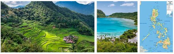
Morphology. – The Philippines are the result of recent orotectonic movements: hence the tormented aspect of the landscape, rich in mountainous areas, volcanic phenomena, with scarce flat areas, usually peripheral, the result of very recent sedimentations. The coasts are usually very indented, rich in peninsulas and inlets. Numerous volcanoes and frequent telluric phenomena, some of which are truly disastrous (earthquakes of 1616, 1796, 1824, 1863; explosion of the Taal volcano in 1911). The islands are essentially mountainous: in Luzon we have three orders of chains, arranged in the direction of the meridians: the eastern or Sierra Madre; the Central Cordillera, with peaks above 2000 m. (Mount Pulog, 2924 m.): In the middle extends the wide and fertile valley of the Cagayan river, the largest river in the island, the western chain or Sierra of Zambales: with the previous one it identifies the depression, which goes with a meridian direction from N. to S from the Gulf of Lingayen to the Bay of Manila, an ancient arm of the sea, covered by floods and volcanic tuffs. The wide delta of the Pampanga River opens into Manila Bay. Numerous rows of volcanoes line up in the SE section. of the island, forming the backbone of the Camarines peninsula: here the Mayon volcano rises to m. 2421 its cone, which closely resembles the Japanese Fuji-yama. wide delta of the Pampanga river. Numerous rows of volcanoes line up in the SE section. of the island, forming the backbone of the Camarines peninsula: here the Mayon volcano rises to m. 2421 its cone, which closely resembles the Japanese Fuji-yama. wide delta of the Pampanga river. Numerous rows of volcanoes line up in the SE section. of the island, forming the backbone of the Camarines peninsula: here the Mayon volcano rises to m. 2421 its cone, which closely resembles the Japanese Fuji-yama.
The relief of Mindanao is very discontinuous: there is a continuous chain at the eastern end, but to the west of the Gulf of Davao there are isolated eruptive massifs, such as the Matutum and the Apo volcano, which is the highest peak of the archipelago (m. 2929), or irregular groups of high peaks extending in the southern part of the island and around Lake Lanao, occupying the central section of a basaltic plateau. In the western section is the large peninsula of Zamboanga, which constitutes a large part of the territory of the province of the same name. Numerous plains are occupied by lakes and ponds, crossed by important rivers, such as the Agusan, which flows into the Mindanao Sea after crossing a dense, almost uninhabited, marshy jungle; the Cotabato or Rio Grande, which flows into the Bay of Illana, collecting the waters of the Buluan, Liguasan, Libungan lakes, from the fluctuating level according to the seasons. Cotabato has risen on the bay, which could become one of the most important emporiums of the archipelago, when the island is fully exploited.
Climate. – Given the geographical position, the Philippines has a typically equatorial climate, especially as regards temperatures, always above 25 °, with very weak annual excursions. These, of course, increase towards the north: so Zamboanga in the Mindanao island has an average annual temperature of 26 °, 6 ° and an excursion of 0 °, 6 °; Manila has 26th, 4th and 3rd, 7th respectively; Aparri, in the northern part of Luzon, 25 °, 8 ° of average annual temperature and 5 °, 1 ° of annual excursion. Precipitation is extraordinarily abundant: out of 70 pluviometric stations, 47 show more than 2 meters of rain a year; 14 exceed 3 meters. The wettest station would be Bagnio (Luzon) with 4527 mm. The annual distribution of precipitation presents considerable differences between one part of the archipelago and the other,
Population. – From a demographic point of view, the Philippines has a very significant increase in population. This was, according to the 1903 census, of 7,637,426 individuals, which had risen to 10,314,310 in 1918, the year of the second census. In 1928 the total number of residents was 12,604,100 (43 residents per sq. Km.). The density has very different values between part and part. A single city exceeds 10,000 residents: Manila, the capital of the colony and the largest port of the archipelago (320,500 residents In 1927; see manila). The other most populated cities are: Cebu, on the island of the same name, with 65,500 residents, the second port of the archipelago; Legazpi, in Luzon 52,766 residents; Iloilo, on Panay Island, with 49,114 residents; Lipa (Luzon), with 46,700 residents; Batangas (Luzon) with 41,100 residents; Ormoc (Leyte), with 38,250 residents; Baybay (Leyte), with 37,000 residents, Etc. Foreigners residing in the Philippines in 1918 were 64,000 divided as follows: Chinese, 43,800, Japanese 7800, Americans 5800, Spaniards, 3900, English 1140, etc.
As regards occupations, in 1918 there were the following percentage divisions: agricultural workers 40.4%; to domestic services 28.8%; to industries 13.4%, to professions 10.7%.